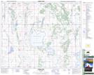
Maps showing Tway, 29-43-24-W2, Saskatchewan
Tway is a Hamlet located in 29-43-24-W2, Saskatchewan and has an elevation of 536 meters.
- Latitude: 52° 44' 20'' North (decimal: 52.7387943)
- Longitude: 105° 26' 20'' West (decimal: -105.4387583)
- Topography Feature Category: Hamlet
- Geographical Feature: Organized Hamlet
- Canadian Province/Territory: Saskatchewan
- Elevation: 536 meters
- Location: 29-43-24-W2
- Atlas of Canada Locator Map: Tway
- GPS Coordinate Locator Map: Tway Lat/Long