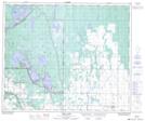
Maps showing Fairy Island Wildlife Refuge, Saskatchewan
Fairy Island Wildlife Refuge is a Conservation area located in Saskatchewan.
- Latitude: 53° 37' 7'' North (decimal: 53.6186606)
- Longitude: 105° 56' 47'' West (decimal: -105.9463314)
- Topography Feature Category: Conservation area
- Geographical Feature: Wildlife Refuge
- Canadian Province/Territory: Saskatchewan
- Atlas of Canada Locator Map: Fairy Island Wildlife Refuge
- GPS Coordinate Locator Map: Fairy Island Wildlife Refuge Lat/Long
Fairy Island Wildlife Refuge NTS Map Sheets