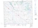
Maps showing Horseshoe Lake Wildlife Refuge, Saskatchewan
Horseshoe Lake Wildlife Refuge is a Conservation area located in Saskatchewan.
- Latitude: 51° 28' North (decimal: 51.4666617)
- Longitude: 102° 36' West (decimal: -102.6004784)
- Topography Feature Category: Conservation area
- Geographical Feature: Wildlife Refuge
- Canadian Province/Territory: Saskatchewan
- Atlas of Canada Locator Map: Horseshoe Lake Wildlife Refuge
- GPS Coordinate Locator Map: Horseshoe Lake Wildlife Refuge Lat/Long