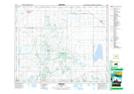
Maps showing Ingvald Opseth Wildlife Refuge, Saskatchewan
Ingvald Opseth Wildlife Refuge is a Conservation area located in Saskatchewan.
- Latitude: 52° 51' North (decimal: 52.8500265)
- Longitude: 105° 21' West (decimal: -105.3505187)
- Topography Feature Category: Conservation area
- Geographical Feature: Wildlife Refuge
- Canadian Province/Territory: Saskatchewan
- Atlas of Canada Locator Map: Ingvald Opseth Wildlife Refuge
- GPS Coordinate Locator Map: Ingvald Opseth Wildlife Refuge Lat/Long