Maps showing Nisbet Provincial Forest, Saskatchewan
Nisbet Provincial Forest is a Conservation area located in Saskatchewan.
- Latitude: 53° 14' North (decimal: 53.2333740)
- Longitude: 105° 45' West (decimal: -105.7505063)
- Topography Feature Category: Conservation area
- Geographical Feature: Provincial Forest
- Canadian Province/Territory: Saskatchewan
- Atlas of Canada Locator Map: Nisbet Provincial Forest
- GPS Coordinate Locator Map: Nisbet Provincial Forest Lat/Long
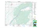
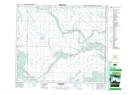
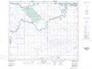
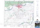
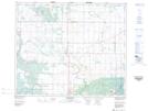
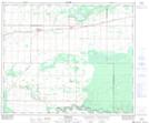
Nisbet Provincial Forest NTS Map Sheets
073B16 Duck Lake Topographic Map at 1:50,000 scale
073G01 Shellbrook Topographic Map at 1:50,000 scale
073G08 Wild Rose Topographic Map at 1:50,000 scale
073H03 Peonan Lake Topographic Map at 1:50,000 scale
073H04 Prince Albert Topographic Map at 1:50,000 scale
073H05 Henribourg Topographic Map at 1:50,000 scale
073H06 Weirdale Topographic Map at 1:50,000 scale
073B Saskatoon Topographic Map at 1:250,000 scale
073G Shellbrook Topographic Map at 1:250,000 scale
073H Prince Albert Topographic Map at 1:250,000 scale