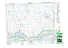
Maps showing Bird's Point Recreation Site, 28-18-3-W2, Saskatchewan
Bird's Point Recreation Site is a Conservation area located in 28-18-3-W2, Saskatchewan and has an elevation of 440 meters.
- Latitude: 50° 32' 46'' North (decimal: 50.5461792)
- Longitude: 102° 22' 13'' West (decimal: -102.3701629)
- Topography Feature Category: Conservation area
- Geographical Feature: Recreation Site
- Canadian Province/Territory: Saskatchewan
- Elevation: 440 meters
- Location: 28-18-3-W2
- Atlas of Canada Locator Map: Bird's Point Recreation Site
- GPS Coordinate Locator Map: Bird's Point Recreation Site Lat/Long