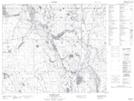
Maps showing Piprell Lake Recreation Site, 60-20-W2, Saskatchewan
Piprell Lake Recreation Site is a Conservation area located in 60-20-W2, Saskatchewan.
- Latitude: 54° 9' 17'' North (decimal: 54.1546014)
- Longitude: 104° 54' 8'' West (decimal: -104.9022647)
- Topography Feature Category: Conservation area
- Geographical Feature: Recreation Site
- Canadian Province/Territory: Saskatchewan
- Location: 60-20-W2
- Atlas of Canada Locator Map: Piprell Lake Recreation Site
- GPS Coordinate Locator Map: Piprell Lake Recreation Site Lat/Long
Piprell Lake Recreation Site NTS Map Sheets