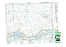
Maps showing Esterhazy Regional Park, 19-1-W2, Saskatchewan
Esterhazy Regional Park is a Conservation area located in 19-1-W2, Saskatchewan and has an elevation of 492 meters.
- Latitude: 50° 39' 30'' North (decimal: 50.6583370)
- Longitude: 102° 3' 32'' West (decimal: -102.0588103)
- Topography Feature Category: Conservation area
- Geographical Feature: Regional Park
- Canadian Province/Territory: Saskatchewan
- Elevation: 492 meters
- Location: 19-1-W2
- Atlas of Canada Locator Map: Esterhazy Regional Park
- GPS Coordinate Locator Map: Esterhazy Regional Park Lat/Long