Maps showing Jean Louis Legare Regional Park, 5-28-W2, Saskatchewan
Jean Louis Legare Regional Park is a Conservation area located in 5-28-W2, Saskatchewan and has an elevation of 823 meters.
- Latitude: 49° 22' 6'' North (decimal: 49.3683617)
- Longitude: 105° 38' 10'' West (decimal: -105.6361174)
- Topography Feature Category: Conservation area
- Geographical Feature: Regional Park
- Canadian Province/Territory: Saskatchewan
- Elevation: 823 meters
- Location: 5-28-W2
- Atlas of Canada Locator Map: Jean Louis Legare Regional Park
- GPS Coordinate Locator Map: Jean Louis Legare Regional Park Lat/Long
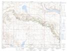
Jean Louis Legare Regional Park NTS Map Sheets