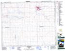
Maps showing Kindersley Regional Park, 28-23-W3, Saskatchewan
Kindersley Regional Park is a Conservation area located in 28-23-W3, Saskatchewan and has an elevation of 682 meters.
- Latitude: 51° 27' 20'' North (decimal: 51.4556112)
- Longitude: 109° 8' 3'' West (decimal: -109.1340732)
- Topography Feature Category: Conservation area
- Geographical Feature: Regional Park
- Canadian Province/Territory: Saskatchewan
- Elevation: 682 meters
- Location: 28-23-W3
- Atlas of Canada Locator Map: Kindersley Regional Park
- GPS Coordinate Locator Map: Kindersley Regional Park Lat/Long
Kindersley Regional Park NTS Map Sheets