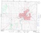
Maps showing Cedar Villa Estates, 15-36-6-W3, Saskatchewan
Cedar Villa Estates is a Hamlet located in 15-36-6-W3, Saskatchewan.
- Latitude: 52° 5' 47'' North (decimal: 52.0965221)
- Longitude: 106° 46' 18'' West (decimal: -106.7715944)
- Topography Feature Category: Hamlet
- Geographical Feature: Organized Hamlet
- Canadian Province/Territory: Saskatchewan
- Location: 15-36-6-W3
- Atlas of Canada Locator Map: Cedar Villa Estates
- GPS Coordinate Locator Map: Cedar Villa Estates Lat/Long
Cedar Villa Estates NTS Map Sheets