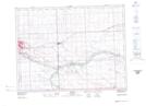
Maps showing La Roche Percee Historic Site, Saskatchewan
La Roche Percee Historic Site is a Conservation area located in Saskatchewan.
- Latitude: 49° 4' 4'' North (decimal: 49.0676666)
- Longitude: 102° 47' 45'' West (decimal: -102.7957838)
- Topography Feature Category: Conservation area
- Geographical Feature: Provincial Historic Site
- Canadian Province/Territory: Saskatchewan
- Atlas of Canada Locator Map: La Roche Percee Historic Site
- GPS Coordinate Locator Map: La Roche Percee Historic Site Lat/Long