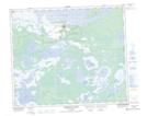
Maps showing Cumberland 20, 21-57-2-W2, Saskatchewan
Cumberland 20 is a Indian Reserve located in 21-57-2-W2, Saskatchewan.
- Latitude: 53° 56' 0'' North (decimal: 53.9334453)
- Longitude: 102° 14' 57'' West (decimal: -102.2491149)
- Topography Feature Category: Indian Reserve
- Geographical Feature: Indian Reserve - Réserve indienne
- Canadian Province/Territory: Saskatchewan
- Location: 21-57-2-W2
- Atlas of Canada Locator Map: Cumberland 20
- GPS Coordinate Locator Map: Cumberland 20 Lat/Long
Cumberland 20 NTS Map Sheets