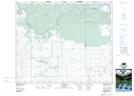
Maps showing Cumberland 100A, 22,23,24-47,48-19,20,21-W2, Saskatchewan
Cumberland 100A is a Indian Reserve located in 22,23,24-47,48-19,20,21-W2, Saskatchewan.
- Latitude: 53° 2' 55'' North (decimal: 53.0485845)
- Longitude: 104° 50' 27'' West (decimal: -104.8407139)
- Topography Feature Category: Indian Reserve
- Geographical Feature: Indian Reserve - Réserve indienne
- Canadian Province/Territory: Saskatchewan
- Location: 22,23,24-47,48-19,20,21-W2
- Atlas of Canada Locator Map: Cumberland 100A
- GPS Coordinate Locator Map: Cumberland 100A Lat/Long
Cumberland 100A NTS Map Sheets