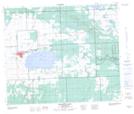
Maps showing Flying Dust First Nation 105, 59, 60-16, 17-W3, Saskatchewan
Flying Dust First Nation 105 is a Indian Reserve located in 59, 60-16, 17-W3, Saskatchewan.
- Latitude: 54° 9' 26'' North (decimal: 54.1572376)
- Longitude: 108° 23' 10'' West (decimal: -108.3861145)
- Topography Feature Category: Indian Reserve
- Geographical Feature: Indian Reserve - Réserve indienne
- Canadian Province/Territory: Saskatchewan
- Location: 59, 60-16, 17-W3
- Atlas of Canada Locator Map: Flying Dust First Nation 105
- GPS Coordinate Locator Map: Flying Dust First Nation 105 Lat/Long
Flying Dust First Nation 105 NTS Map Sheets