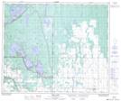
Maps showing Little Red River 106C, 52-26,27,28-W2; 52-1-W3, Saskatchewan
Little Red River 106C is a Indian Reserve located in 52-26,27,28-W2; 52-1-W3, Saskatchewan.
- Latitude: 53° 30' 13'' North (decimal: 53.5036645)
- Longitude: 105° 57' 26'' West (decimal: -105.9572517)
- Topography Feature Category: Indian Reserve
- Geographical Feature: Indian Reserve - Réserve indienne
- Canadian Province/Territory: Saskatchewan
- Location: 52-26,27,28-W2; 52-1-W3
- Atlas of Canada Locator Map: Little Red River 106C
- GPS Coordinate Locator Map: Little Red River 106C Lat/Long
Little Red River 106C NTS Map Sheets