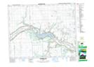
Maps showing Ochapowace 71-19, 19-5-W2, Saskatchewan
Ochapowace 71-19 is a Indian Reserve located in 19-5-W2, Saskatchewan.
- Latitude: 50° 37' 8'' North (decimal: 50.6189741)
- Longitude: 102° 41' 47'' West (decimal: -102.6962769)
- Topography Feature Category: Indian Reserve
- Geographical Feature: Indian Reserve - Réserve indienne
- Canadian Province/Territory: Saskatchewan
- Location: 19-5-W2
- Atlas of Canada Locator Map: Ochapowace 71-19
- GPS Coordinate Locator Map: Ochapowace 71-19 Lat/Long
Ochapowace 71-19 NTS Map Sheets