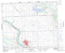
Maps showing Saulteaux 159B, 24-44-16-W3, Saskatchewan
Saulteaux 159B is a Indian Reserve located in 24-44-16-W3, Saskatchewan.
- Latitude: 52° 48' 43'' North (decimal: 52.8120702)
- Longitude: 108° 17' 59'' West (decimal: -108.2998251)
- Topography Feature Category: Indian Reserve
- Geographical Feature: Indian Reserve - Réserve indienne
- Canadian Province/Territory: Saskatchewan
- Location: 24-44-16-W3
- Atlas of Canada Locator Map: Saulteaux 159B
- GPS Coordinate Locator Map: Saulteaux 159B Lat/Long
Saulteaux 159B NTS Map Sheets