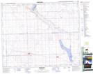
Maps showing Opuntia Lake Bird Sanctuary, Saskatchewan
Opuntia Lake Bird Sanctuary is a Conservation area located in Saskatchewan.
- Latitude: 51° 48' North (decimal: 51.8000542)
- Longitude: 108° 34' West (decimal: -108.5673797)
- Topography Feature Category: Conservation area
- Geographical Feature: Migratory Bird Sanctuary
- Canadian Province/Territory: Saskatchewan
- Atlas of Canada Locator Map: Opuntia Lake Bird Sanctuary
- GPS Coordinate Locator Map: Opuntia Lake Bird Sanctuary Lat/Long
Opuntia Lake Bird Sanctuary NTS Map Sheets