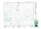
Maps showing Carry The Kettle Nakoda First Nation 76-6, Saskatchewan
Carry The Kettle Nakoda First Nation 76-6 is a Indian Reserve located in Saskatchewan.
- Latitude: 50° 27' 45'' North (decimal: 50.4625202)
- Longitude: 103° 10' 50'' West (decimal: -103.1805858)
- Topography Feature Category: Indian Reserve
- Geographical Feature: Indian Reserve - Réserve indienne
- Canadian Province/Territory: Saskatchewan
- Atlas of Canada Locator Map: Carry The Kettle Nakoda First Nation 76-6
- GPS Coordinate Locator Map: Carry The Kettle Nakoda First Nation 76-6 Lat/Long