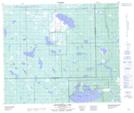
Maps showing Thunderchild First Nation 115X, Saskatchewan
Thunderchild First Nation 115X is a Indian Reserve located in Saskatchewan.
- Latitude: 54° 7' 20'' North (decimal: 54.1222815)
- Longitude: 109° 52' 18'' West (decimal: -109.8715466)
- Topography Feature Category: Indian Reserve
- Geographical Feature: Indian Reserve - Réserve indienne
- Canadian Province/Territory: Saskatchewan
- Atlas of Canada Locator Map: Thunderchild First Nation 115X
- GPS Coordinate Locator Map: Thunderchild First Nation 115X Lat/Long
Thunderchild First Nation 115X NTS Map Sheets