Maps showing Sakimay 74-10, Saskatchewan
Sakimay 74-10 is a Indian Reserve located in Saskatchewan.
- Latitude: 50° 57' 22'' North (decimal: 50.9559812)
- Longitude: 102° 22' 50'' West (decimal: -102.3806124)
- Topography Feature Category: Indian Reserve
- Geographical Feature: Indian Reserve - Réserve indienne
- Canadian Province/Territory: Saskatchewan
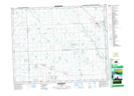
- Atlas of Canada Locator Map: Sakimay 74-10
- GPS Coordinate Locator Map: Sakimay 74-10 Lat/Long
Sakimay 74-10 NTS Map Sheets