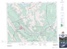
Maps showing Dead Man Flat, 13-24-10-W5, Alberta
Dead Man Flat is a Plain located in 13-24-10-W5, Alberta and has an elevation of 1320 meters.
- Latitude: 51° 2' 25'' North (decimal: 51.0402777)
- Longitude: 115° 16' 25'' West (decimal: -115.2736111)
- Topography Feature Category: Plain
- Geographical Feature: Flat
- Canadian Province/Territory: Alberta
- Elevation: 1320 meters
- Location: 13-24-10-W5
- Atlas of Canada Locator Map: Dead Man Flat
- GPS Coordinate Locator Map: Dead Man Flat Lat/Long