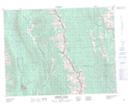
Maps showing Beehive Pass, 7-13-5-W5M, Alberta
Beehive Pass is a Valley located in 7-13-5-W5M, Alberta.
- Latitude: 50° 3' 50'' North (decimal: 50.0638888)
- Longitude: 114° 40' 33'' West (decimal: -114.6758333)
- Topography Feature Category: Valley
- Geographical Feature: Pass
- Canadian Province/Territory: Alberta
- Location: 7-13-5-W5M
- Atlas of Canada Locator Map: Beehive Pass
- GPS Coordinate Locator Map: Beehive Pass Lat/Long
Beehive Pass NTS Map Sheets