Maps showing MacArthur Siding, 36-54-25-W4, Alberta
MacArthur Siding is a Unincorporated area located in 36-54-25-W4, Alberta.
- Latitude: 53° 42' 30'' North (decimal: 53.7082999)
- Longitude: 113° 33' 15'' West (decimal: -113.5542000)
- Topography Feature Category: Unincorporated area
- Geographical Feature: Railway Point
- Canadian Province/Territory: Alberta
- Location: 36-54-25-W4
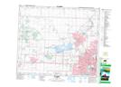
- Atlas of Canada Locator Map: MacArthur Siding
- GPS Coordinate Locator Map: MacArthur Siding Lat/Long