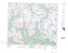
Maps showing Mount Phillips, 48-9-W6, Alberta
Mount Phillips is a Mountain located in 48-9-W6, Alberta and has an elevation of 2871 meters.
- Latitude: 53° 10' 39'' North (decimal: 53.1775000)
- Longitude: 119° 15' 37'' West (decimal: -119.2602777)
- Topography Feature Category: Mountain
- Geographical Feature: Mount
- Canadian Province/Territory: Alberta
- Elevation: 2871 meters
- Location: 48-9-W6
- Atlas of Canada Locator Map: Mount Phillips
- GPS Coordinate Locator Map: Mount Phillips Lat/Long
Mount Phillips NTS Map Sheets