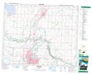
Maps showing Labuma, 10-39-27-W4, Alberta
Labuma is a Unincorporated area located in 10-39-27-W4, Alberta.
- Latitude: 52° 20' 8'' North (decimal: 52.3355555)
- Longitude: 113° 47' 57'' West (decimal: -113.7991667)
- Topography Feature Category: Unincorporated area
- Geographical Feature: Locality
- Canadian Province/Territory: Alberta
- Location: 10-39-27-W4
- Atlas of Canada Locator Map: Labuma
- GPS Coordinate Locator Map: Labuma Lat/Long