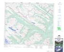
Maps showing The Ancient Wall, 51-6,7-W6, Alberta
The Ancient Wall is a Mountain located in 51-6,7-W6, Alberta and has an elevation of 2079 meters.
- Latitude: 53° 27' 21'' North (decimal: 53.4559703)
- Longitude: 118° 56' 5'' West (decimal: -118.9346194)
- Topography Feature Category: Mountain
- Geographical Feature: Ridge
- Canadian Province/Territory: Alberta
- Elevation: 2079 meters
- Location: 51-6,7-W6
- Atlas of Canada Locator Map: The Ancient Wall
- GPS Coordinate Locator Map: The Ancient Wall Lat/Long
The Ancient Wall NTS Map Sheets