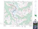
Maps showing Angel Glacier, 43-1-W6, Alberta
Angel Glacier is a Glacier located in 43-1-W6, Alberta and has an elevation of 2546 meters.
- Latitude: 52° 40' 36'' North (decimal: 52.6766666)
- Longitude: 118° 3' 44'' West (decimal: -118.0622221)
- Topography Feature Category: Glacier
- Geographical Feature: Glacier
- Canadian Province/Territory: Alberta
- Elevation: 2546 meters
- Location: 43-1-W6
- Atlas of Canada Locator Map: Angel Glacier
- GPS Coordinate Locator Map: Angel Glacier Lat/Long
Angel Glacier NTS Map Sheets