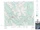
Maps showing Policeman Creek, 28-24-10-W5, Alberta
Policeman Creek is a River located in 28-24-10-W5, Alberta and has an elevation of 1307 meters.
- Latitude: 51° 4' 5'' North (decimal: 51.0680555)
- Longitude: 115° 19' 58'' West (decimal: -115.3327777)
- Topography Feature Category: River
- Geographical Feature: Creek
- Canadian Province/Territory: Alberta
- Elevation: 1307 meters
- Location: 28-24-10-W5
- Atlas of Canada Locator Map: Policeman Creek
- GPS Coordinate Locator Map: Policeman Creek Lat/Long