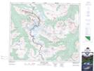
Maps showing The Portal, 43-1-W6, Alberta
The Portal is a Valley located in 43-1-W6, Alberta and has an elevation of 1988 meters.
- Latitude: 52° 44' 49'' North (decimal: 52.7469444)
- Longitude: 118° 8' 42'' West (decimal: -118.1450000)
- Topography Feature Category: Valley
- Geographical Feature: Pass
- Canadian Province/Territory: Alberta
- Elevation: 1988 meters
- Location: 43-1-W6
- Atlas of Canada Locator Map: The Portal
- GPS Coordinate Locator Map: The Portal Lat/Long
The Portal NTS Map Sheets