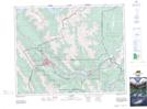
Maps showing Association Peak, 36-25-9-W5, Alberta
Association Peak is a Mountain located in 36-25-9-W5, Alberta and has an elevation of 2105 meters.
- Latitude: 51° 10' 50'' North (decimal: 51.1805555)
- Longitude: 115° 7' 34'' West (decimal: -115.1261110)
- Topography Feature Category: Mountain
- Geographical Feature: Peak
- Canadian Province/Territory: Alberta
- Elevation: 2105 meters
- Location: 36-25-9-W5
- Atlas of Canada Locator Map: Association Peak
- GPS Coordinate Locator Map: Association Peak Lat/Long