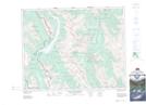
Maps showing Mount Engadine, 22-10-W5, Alberta
Mount Engadine is a Mountain located in 22-10-W5, Alberta and has an elevation of 2630 meters.
- Latitude: 50° 51' 53'' North (decimal: 50.8647222)
- Longitude: 115° 18' 39'' West (decimal: -115.3108333)
- Topography Feature Category: Mountain
- Geographical Feature: Mount
- Canadian Province/Territory: Alberta
- Elevation: 2630 meters
- Location: 22-10-W5
- Atlas of Canada Locator Map: Mount Engadine
- GPS Coordinate Locator Map: Mount Engadine Lat/Long
Mount Engadine NTS Map Sheets