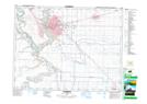
Maps showing Lenzie, 10-9-22-W4, Alberta
Lenzie is a Unincorporated area located in 10-9-22-W4, Alberta.
- Latitude: 49° 42' 54'' North (decimal: 49.7150000)
- Longitude: 112° 54' 16'' West (decimal: -112.9044443)
- Topography Feature Category: Unincorporated area
- Geographical Feature: Locality
- Canadian Province/Territory: Alberta
- Location: 10-9-22-W4
- Atlas of Canada Locator Map: Lenzie
- GPS Coordinate Locator Map: Lenzie Lat/Long
Lenzie NTS Map Sheets