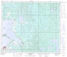
Maps showing Barnegat, 8-67-12-W4, Alberta
Barnegat is a Unincorporated area located in 8-67-12-W4, Alberta and has an elevation of 552 meters.
- Latitude: 54° 47' 33'' North (decimal: 54.7924999)
- Longitude: 111° 49' 36'' West (decimal: -111.8266666)
- Topography Feature Category: Unincorporated area
- Geographical Feature: Locality
- Canadian Province/Territory: Alberta
- Elevation: 552 meters
- Location: 8-67-12-W4
- Atlas of Canada Locator Map: Barnegat
- GPS Coordinate Locator Map: Barnegat Lat/Long
Barnegat NTS Map Sheets