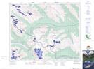
Maps showing Lake of Falls, 9,10-36-19-W5, Alberta
Lake of Falls is a Lake located in 9,10-36-19-W5, Alberta and has an elevation of 2165 meters.
- Latitude: 52° 5' 6'' North (decimal: 52.0849999)
- Longitude: 116° 37' 43'' West (decimal: -116.6286111)
- Topography Feature Category: Lake
- Geographical Feature: Lake
- Canadian Province/Territory: Alberta
- Elevation: 2165 meters
- Location: 9,10-36-19-W5
- Atlas of Canada Locator Map: Lake of Falls
- GPS Coordinate Locator Map: Lake of Falls Lat/Long
Lake of Falls NTS Map Sheets