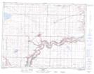
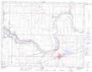
Maps showing Arrowsmith Coulee, 27-11-19-W4, Alberta
Arrowsmith Coulee is a Valley located in 27-11-19-W4, Alberta and has an elevation of 826 meters.
- Latitude: 49° 56' 8'' North (decimal: 49.9355555)
- Longitude: 112° 30' 33'' West (decimal: -112.5091666)
- Topography Feature Category: Valley
- Geographical Feature: Coulee
- Canadian Province/Territory: Alberta
- Elevation: 826 meters
- Location: 27-11-19-W4
- Atlas of Canada Locator Map: Arrowsmith Coulee
- GPS Coordinate Locator Map: Arrowsmith Coulee Lat/Long
Arrowsmith Coulee NTS Map Sheets