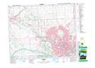
Maps showing Prince Island, 21-24-1-W5, Alberta
Prince Island is a Island located in 21-24-1-W5, Alberta and has an elevation of 1052 meters.
- Latitude: 51° 3' 19'' North (decimal: 51.0552777)
- Longitude: 114° 4' 15'' West (decimal: -114.0708333)
- Topography Feature Category: Island
- Geographical Feature: Island
- Canadian Province/Territory: Alberta
- Elevation: 1052 meters
- Location: 21-24-1-W5
- Atlas of Canada Locator Map: Prince Island
- GPS Coordinate Locator Map: Prince Island Lat/Long