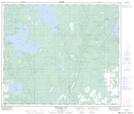
Maps showing Pullar Lake, 18-66-9-W4, Alberta
Pullar Lake is a Lake located in 18-66-9-W4, Alberta and has an elevation of 635 meters.
- Latitude: 54° 42' 57'' North (decimal: 54.7158328)
- Longitude: 111° 21' 31'' West (decimal: -111.3586098)
- Topography Feature Category: Lake
- Geographical Feature: Lake
- Canadian Province/Territory: Alberta
- Elevation: 635 meters
- Location: 18-66-9-W4
- Atlas of Canada Locator Map: Pullar Lake
- GPS Coordinate Locator Map: Pullar Lake Lat/Long
Pullar Lake NTS Map Sheets