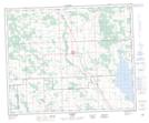
Maps showing Lockhart, 18-41-2-W5, Alberta
Lockhart is a Unincorporated area located in 18-41-2-W5, Alberta and has an elevation of 957 meters.
- Latitude: 52° 31' 50'' North (decimal: 52.5305555)
- Longitude: 114° 15' 56'' West (decimal: -114.2655555)
- Topography Feature Category: Unincorporated area
- Geographical Feature: Former Locality
- Canadian Province/Territory: Alberta
- Elevation: 957 meters
- Location: 18-41-2-W5
- Atlas of Canada Locator Map: Lockhart
- GPS Coordinate Locator Map: Lockhart Lat/Long
Lockhart NTS Map Sheets