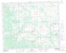
Maps showing Beaver Lake, 16-35-6-W5, Alberta
Beaver Lake is a Lake located in 16-35-6-W5, Alberta and has an elevation of 1165 meters.
- Latitude: 52° 0' 23'' North (decimal: 52.0063889)
- Longitude: 114° 47' 17'' West (decimal: -114.7880555)
- Topography Feature Category: Lake
- Geographical Feature: Lake
- Canadian Province/Territory: Alberta
- Elevation: 1165 meters
- Location: 16-35-6-W5
- Atlas of Canada Locator Map: Beaver Lake
- GPS Coordinate Locator Map: Beaver Lake Lat/Long
Beaver Lake NTS Map Sheets