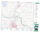
Maps showing Red Deer Junction, 11-39-27-W4, Alberta
Red Deer Junction is a Unincorporated area located in 11-39-27-W4, Alberta and has an elevation of 859 meters.
- Latitude: 52° 21' 2'' North (decimal: 52.3505555)
- Longitude: 113° 47' 5'' West (decimal: -113.7847221)
- Topography Feature Category: Unincorporated area
- Geographical Feature: Locality
- Canadian Province/Territory: Alberta
- Elevation: 859 meters
- Location: 11-39-27-W4
- Atlas of Canada Locator Map: Red Deer Junction
- GPS Coordinate Locator Map: Red Deer Junction Lat/Long