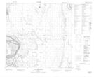
Maps showing Peltier Creek, 116-10-W4, Alberta
Peltier Creek is a River located in 116-10-W4, Alberta.
- Latitude: 59° 6' 8'' North (decimal: 59.1022222)
- Longitude: 111° 33' 28'' West (decimal: -111.5577778)
- Topography Feature Category: River
- Geographical Feature: Creek
- Canadian Province/Territory: Alberta
- Location: 116-10-W4
- Atlas of Canada Locator Map: Peltier Creek
- GPS Coordinate Locator Map: Peltier Creek Lat/Long
Peltier Creek NTS Map Sheets