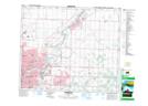
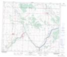
Maps showing Fort Saskatchewan, 32-54-22-W4, Alberta
Fort Saskatchewan is a City located in 32-54-22-W4, Alberta and has an elevation of 621 meters.
- Latitude: 53° 42' 40'' North (decimal: 53.7111110)
- Longitude: 113° 13' 4'' West (decimal: -113.2177777)
- Topography Feature Category: City
- Geographical Feature: City
- Canadian Province/Territory: Alberta
- Elevation: 621 meters
- Location: 32-54-22-W4
- Atlas of Canada Locator Map: Fort Saskatchewan
- GPS Coordinate Locator Map: Fort Saskatchewan Lat/Long
Fort Saskatchewan NTS Map Sheets