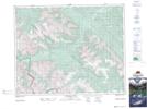
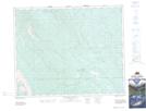
Maps showing Rocky Creek, 35-11-W5, Alberta
Rocky Creek is a River located in 35-11-W5, Alberta.
- Latitude: 51° 59' 38'' North (decimal: 51.9938888)
- Longitude: 115° 28' 9'' West (decimal: -115.4691666)
- Topography Feature Category: River
- Geographical Feature: Creek
- Canadian Province/Territory: Alberta
- Location: 35-11-W5
- Atlas of Canada Locator Map: Rocky Creek
- GPS Coordinate Locator Map: Rocky Creek Lat/Long
Rocky Creek NTS Map Sheets