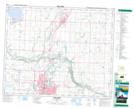
Maps showing Gaetz Lakes, 38-27-W4, Alberta
Gaetz Lakes is a Lake located in 38-27-W4, Alberta and has an elevation of 860 meters.
- Latitude: 52° 16' 57'' North (decimal: 52.2825000)
- Longitude: 113° 46' 58'' West (decimal: -113.7827778)
- Topography Feature Category: Lake
- Geographical Feature: Lakes
- Canadian Province/Territory: Alberta
- Elevation: 860 meters
- Location: 38-27-W4
- Atlas of Canada Locator Map: Gaetz Lakes
- GPS Coordinate Locator Map: Gaetz Lakes Lat/Long