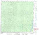
Maps showing Bird Island, 99-10-W4, Alberta
Bird Island is a Island located in 99-10-W4, Alberta and has an elevation of 225 meters.
- Latitude: 57° 35' 45'' North (decimal: 57.5958333)
- Longitude: 111° 30' 39'' West (decimal: -111.5108332)
- Topography Feature Category: Island
- Geographical Feature: Island
- Canadian Province/Territory: Alberta
- Elevation: 225 meters
- Location: 99-10-W4
- Atlas of Canada Locator Map: Bird Island
- GPS Coordinate Locator Map: Bird Island Lat/Long
Bird Island NTS Map Sheets