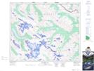
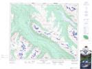
Maps showing Samson Narrows, 42-25-W5, Alberta
Samson Narrows is a Channel located in 42-25-W5, Alberta and has an elevation of 1694 meters.
- Latitude: 52° 38' 41'' North (decimal: 52.6447222)
- Longitude: 117° 30' 9'' West (decimal: -117.5024999)
- Topography Feature Category: Channel
- Geographical Feature: Narrows
- Canadian Province/Territory: Alberta
- Elevation: 1694 meters
- Location: 42-25-W5
- Atlas of Canada Locator Map: Samson Narrows
- GPS Coordinate Locator Map: Samson Narrows Lat/Long
Samson Narrows NTS Map Sheets