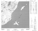
Maps showing Sand Point, 114-5-W4, Alberta
Sand Point is a Cape located in 114-5-W4, Alberta and has an elevation of 222 meters.
- Latitude: 58° 56' 15'' North (decimal: 58.9374999)
- Longitude: 110° 41' 59'' West (decimal: -110.6997222)
- Topography Feature Category: Cape
- Geographical Feature: Point
- Canadian Province/Territory: Alberta
- Elevation: 222 meters
- Location: 114-5-W4
- Atlas of Canada Locator Map: Sand Point
- GPS Coordinate Locator Map: Sand Point Lat/Long
Sand Point NTS Map Sheets