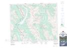
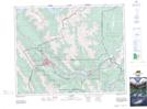
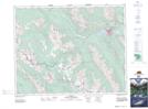
Maps showing Goat Range, 23,24-10,11-W5, Alberta
Goat Range is a Mountain located in 23,24-10,11-W5, Alberta and has an elevation of 2508 meters.
- Latitude: 51° 0' 1'' North (decimal: 51.0003000)
- Longitude: 115° 25' 26'' West (decimal: -115.4239000)
- Topography Feature Category: Mountain
- Geographical Feature: Range
- Canadian Province/Territory: Alberta
- Elevation: 2508 meters
- Location: 23,24-10,11-W5
- Atlas of Canada Locator Map: Goat Range
- GPS Coordinate Locator Map: Goat Range Lat/Long
Goat Range NTS Map Sheets